Beneath Becakayu and Wiyoto Wiyono: Riding Through East Jakarta
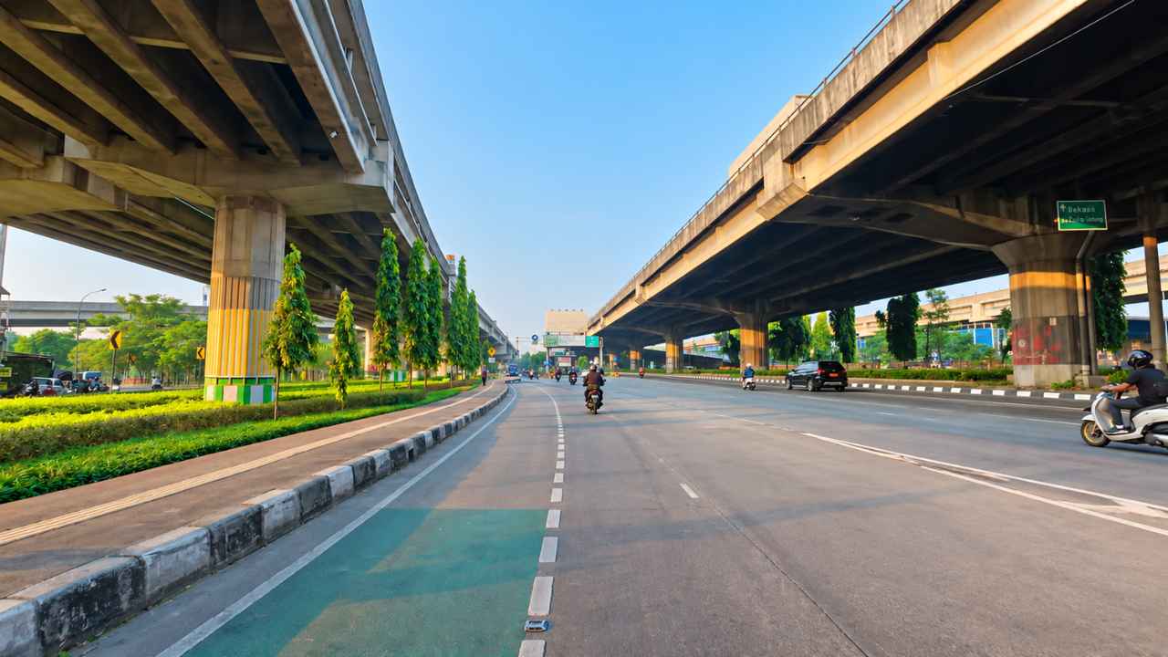
In East Jakarta, a ride along an arterial road can reveal another layer of the city overhead. The elevated structures of Becakayu and Wiyoto Wiyono create a landscape of broad concrete spans, repeated columns and strips of sky. From a motorcycle at street level, the road sometimes feels sheltered by a vast, open-sided canopy.
The distinction matters: this is a look at the ordinary roads beneath or around the elevated toll roads, not a motorcycle journey on the toll carriageways. The supplied material describes corridors around Cawang, Jatinegara, Cipinang and Kalimalang, rather than a turn-by-turn itinerary.
Key facts at a glance
- Area: East Jakarta, around the Cawang, Jatinegara, Cipinang and Kalimalang corridors.
- Becakayu: the Bekasi–Cawang–Kampung Melayu toll road, whose elevated structure follows the Kalimalang corridor towards Bekasi.
- Wiyoto Wiyono: an elevated toll-road network visible around Cawang and Jatinegara, including the Jalan D.I. Panjaitan corridor.
- Street-level perspective: motorcycles remain on the public arterial roads, separate from toll-road access.
- Scope: a visual route feature based on the supplied draft, photograph and linked ride recording, not a live traffic report.
Beneath Becakayu along the Kalimalang corridor
Becakayu gives the Kalimalang corridor a strong visual rhythm. Its large supporting columns repeat along the road, while the elevated deck stretches into the distance. The structure is more than a distant skyline feature: from below, it becomes part of the immediate setting of the journey.
In places, the deck shades the road beneath it. Elsewhere, daylight enters through gaps between structures and along their edges. The result is a sequence of shaded stretches and brighter openings, with roadside trees offering a softer contrast to the concrete.
What the supplied photograph shows
The photograph captures motorcycles and cars beneath elevated spans, with planted verges, slender trees and open blue sky between the structures. The repeating pillars draw the eye ahead, while road markings keep the street-level journey distinct from the infrastructure overhead.
It is a useful illustration of the corridor's appearance, but one photograph cannot establish traffic conditions throughout the day. Nor does it make every nearby stretch look the same: the amount of shade and the view overhead change as the road continues.
Wiyoto Wiyono around Cawang and Jatinegara
Around Cawang and Jatinegara, the material describes a more layered view of the elevated-road network. The Wiyoto Wiyono structures stand above arterial stretches, including the D.I. Panjaitan corridor. From below, decks and columns at different heights form a dense urban backdrop.
For a passing rider, the contrast is between the horizontal task of following a lane and the vertical city above. Cars and motorcycles occupy the road surface; concrete roads cross the field of view overhead. This is a street-level portrait of infrastructure, rather than a claim that the pictured structures all belong to the same toll-road section.
A concrete canopy, not a closed tunnel
The phrase concrete canopy describes the visual effect. Where a span covers much of the sky, the road can resemble a semi-open tunnel. A little farther on, the view opens again and sunlight reaches the carriageway from the sides or between the decks.
Greenery adds another layer to the scene. Trees, planted strips and the sky keep the corridor from being only a study in grey concrete. The appeal lies in this changing composition, not in a promise of an empty road or a particular journey time.
Notes for riders on the arterial roads
- Separate the arterial route from toll access. Check signs before a junction and stay on the public-road route described here; the elevated carriageways are not this motorcycle itinerary.
- Keep attention on the lane ahead. The structures are visually striking, but road markings, nearby vehicles and junctions still need priority.
- Expect changes in light. Shade beneath a deck can give way to a bright opening, so avoid treating the whole corridor as a uniformly sheltered space.
- Assess the road when it rains. Watch for visible puddles, spray and water dripping from above, without assuming the concrete canopy keeps the surface dry.
- Use this as context, not navigation. Confirm your destination and current route separately; this feature does not list every junction or lane choice.
Frequently asked questions
Does this ride use the Becakayu toll road?
No. The motorcycle perspective in this article is from arterial roads beneath or near the elevated structures, not from the main toll carriageway.
Where does the concrete-canopy view appear?
The supplied material places it along the Kalimalang corridor beneath Becakayu and around Cawang, Jatinegara and D.I. Panjaitan near the Wiyoto Wiyono structures. The view varies from one stretch to another.
Is the whole road protected from rain?
No such protection can be assumed. The sides remain open and the cover is not continuous; riders should assess the actual surface and visibility.
Does the photograph show current traffic?
It shows the scene in the supplied image, not real-time conditions. This article does not provide live congestion data or a travel-time estimate.
See East Jakarta from street level
Beneath the elevated roads, an everyday journey becomes a view of how the city uses space above and below. The concrete spans dominate the setting, but motorcycles, cars and roadside greenery bring it back to the scale of an ordinary street.
The source material includes a ride recording on YouTube. For another Jakarta street portrait, read our feature on Benyamin Sueb Street in Kemayoran, or browse the Rider Street View blog.
Tags: Jakarta · Jakarta Timur · Tol Becakayu · Tol Wiyoto Wiyono · DI Panjaitan · Jatinegara · Kalimalang
Discussion
Share what you know about this route. Comments are published straight away, and links are not allowed — write the name of a place instead of a web address.
Loading the discussion…